

Erskine Creek and Dadder Cave, Glenbrook, NSW
- Jul 31, 2025
- 3 min read

Embark on an exciting adventure exploring Erskine Creek in Glenbrook, NSW. This circuit track guides you through a picturesque journey, descending via the Jack Evans Track and ascending Pisgah Rock on your return. Along the route, be sure to visit Dadder Cave or enjoy a swim at Blands Pool. The trail features several inviting waterholes, ideal for a refreshing swim in the pristine waters. These tranquil spots provide a perfect setting for relaxation, allowing you to pause your hike and savor the natural surroundings. The creek offers camping opportunities along the route or at the junction of Erskine Creek and Lincoln Creek. This trail is recommended for experienced hikers, as much of the walk is off-track and involves rock scrambling up to Pisgah Rock. This circuit trail not only offers visual splendor but also provides an opportunity to immerse yourself in the natural beauty and diverse ecosystems of the region.
Overview
This trail presents a moderate challenge, with the majority of the walk being off track. There are some steep sections on the way out, especially if you ascend via Pisgah Rock. The route is unmarked as you descend into the valley and follow the creek.
Trail Details
Starting Point: Jack Evans Track
Finishing Point: Pisgah Rock Trail
Total Distance Covered: 13 km
Total Elevation Gain: 500m
Time Spent: 7 hours
Trail Conditions
Start with easy stroll along the fire trail to Nepean Lookout and back. The start of the Jack Evans Track is pretty well-maintained and easy to follow as you head down. On the Erskine Creek walk, you'll encounter different types of terrain and a few water crossings; just keep in mind that conditions might change depending on the water level. The climb up Pisgah Rock has a few tricky spots that require some rock scrambling. Once you reach Pisgah Rock Lookout, it's an easy, flat path back to the fire trail.
Track notes:
On Sunday morning, we're meeting our hiking friend at Glenbrook Underground Cafe for a quick coffee and breakfast before heading to the start of our walk. It's another 30-minute drive from Glenbrook town along The Oaks Trail and Nepean Lookout Trail.
Erskine Creek and Dadder Cave
We start our walk at the Jack Evans Track. Before descending into the valley, we take a brief stroll to Nepean Lookout, located at the end of Nepean Lookout Trail. This spot offers views of the Nepean River and Erskine Creek.
Jack Evans Track confidently leads you down to Erskine Creek, offering an easy-to-follow path with several lookout points that provide stunning aerial views of the creek.
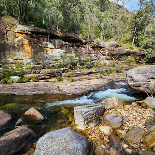
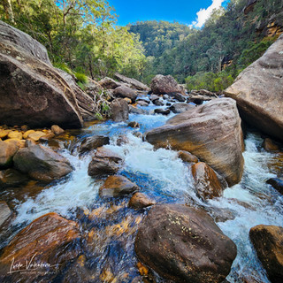
As you head down, you can start following the creek upstream! This exciting route is totally off the beaten path, with no marked trail, and it offers a fun mix of terrains like sandy beaches, rock platforms, big boulders, and areas full of smaller rocks and bushes. You'll have a blast crossing the creek multiple times, especially if you're a bit clumsy and end up getting your shoes wet by falling into the water. There are also tons of awesome swimming spots to discover along the way, making it a great place to visit in the summer or warmer months.
After covering approximately 6.5 km, we arrived at the junction of Erskine Creek and Lincoln Creek. There is another large swimming hole and a beautiful campsite with a pleasant sandy beach. It's an excellent spot to pause for lunch and a bit of relaxation before heading further to check out Dadder Cave.
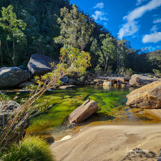
As you keep heading upstream along Erskine Creek, you'll find Dadder Cave, supposedly named after the adder snake. It's basically a big rock overhang, which makes it a great spot for camping. Just a bit further, about a 15-minute walk along the creek, you'll come across another big water hole called Blands Pool. It was my first time visiting this pool, and it's definitely worth another visit. Then head back the same way to the first campsite to start the climb up to Pisgah Rock.
Pisgah Rock features steep ascents and thrilling rock scrambling sections that offer an exciting challenge. While these parts may not suit everyone, the path to the summit is occasionally marked with arrows to guide you across the rock face. Once you reach the Pisgah Rock Lookout, the remainder of the walk is easy and flat, with less than 1km back to the fire trail.
Alltrails link: https://www.alltrails.com/explore/recording/activity-july-27-2025-9379360?u=m&sh=opzdyt


The discussions surrounding Erskine Creek's hiking circuit underscore a critical aspect of outdoor exploration: preparedness. Navigating off-track terrains, particularly with rock scrambling segments, introduces substantial risk. Understanding the challenge posed by such conditions is paramount. Moreover, integrating experiences like swimming in natural pools creates a balanced experience for hikers https://premiertrampolines.com.au/ The Pokies can serve as a metaphor for the unpredictability of nature; one must tread carefully, just as one does with chance games.